Address:
900 E. Broad Street
Richmond, VA
23219 USA
Hours: Mon - Fri (8 a.m. - 5 p.m.)
Phone No. 804-646-6430
Email: Ask Public Works
Capital Projects (CIP) & Transportation Projects
The division's mission is to deliver environmentally sound transportation projects for the Richmond region that are on-time and on-budget, so that people, goods and services can move safely, seamlessly, and efficiently throughout the City of Richmond.
Upcoming and Active CIP Projects
If you know of any areas where capital improvements are needed, perhaps a new sidewalk or curb, just let us know. We will review your request and let you know how much it will cost to fix it. We also will give you information about how and when it may be funded.
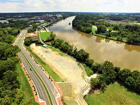
An example of a completed CIP Project - photos of the East River Front Project
Public Meeting Details:
- DUE TO SAFETY CONCERNS RELATED TO THE WEATHER THE DATE HAS BEEN RESCHEDULED TO TUESDAY, FEBRUARY 10, 2026, from 5:00 - 7:00 pm. LOCATION AND TIME REMAIN THE SAME.
- Main Street Train Station
- 1500 E Main St., Richmond, VA 23219
- U000-127-066, STP-5B27(041), (UPC 115410)
Project Manager
Olayinka Bruce EIT, MBA
Project Manager Senior
P|(804) 646-2312
The project aims to enhance pedestrian access and safety in the vicinity of the East Riverfront and Orleans BRT Station. This will be achieved through the construction of sidewalks, ADA accessible ramps, and the installation of pedestrian scale lighting.
Project Description: E Franklin Street/31st Street includes new sidewalks on both sides of the road and pedestrian lighting. A new development is planned on the east side of 31st Street. This development is proposed to construct new sidewalks from E Franklin Street to Williamsburg Road. Admiral Gravely Boulevard between Williamsburg Avenue and Gilliam Street includes pedestrian scale lighting with new curb ramps and cross walks on all approaches of Williamsburg Avenue, Gilliam Street, and Fulton Street. Goddin Street between Williamsburg Avenue and Goddin Court includes pedestrian scale lighting and new sidewalk on the north side with curb ramps at Fulton Street, Goddin Circle and Goddin Court. Williamsburg Avenue between Orleans Street and Hatcher Street includes pedestrian scale lighting and curb ramps at Hatcher Street, Goddin Street, Ohio Street, and Orleans Street. Hatcher Street from Williamsburg Avenue to Nelson Street includes new sidewalk on the east side of road.

Project Information:
- Location: E Franklin St./31st St., Admiral Gravely Blvd., Goddin St., Williamsburg Ave., and Hatcher St.
- Length: Varies by location
- Plans: 60% Plans
- Anticipated Cost*: $2,233,200
- Anticipated Schedule*:
- Right of Way Acquisition: Spring 2027 – Spring 2028
- Utility Relocation: Spring 2028 – Winter 2028
- Construction Start: Summer 2030 – Summer 2031
- Comment Form: Comment Form (Forms need to be submitted prior to February 20, 2026)
- email: Olayinka.Bruce@rva.gov
- Mail: City of Richmond Department of Public Works
City Hall
900 E. Broad Street, Rm. 603
Richmond, VA 23219
Right of Way: Displays at this meeting show the extent of easements and right of way that may be needed as the project is currently proposed. As the design is further developed, additional easements and right of way may be required beyond what is shown on the current plans. Property owners will be informed of the exact location of the easements during the right of way acquisition process and prior to construction.
* The cost and schedule provided are approximate based on the current scope and design and are subject to change. The project is financed by VDOT District Grant Program including State and Federal monies.
Environmental Review: The City of Richmond has performed environmental reviews and coordination to obtain information about environmental resources in the project vicinity; to provide natural and historic resource agencies an opportunity to review and comment on the project during its development; and to identify opportunities to avoid and minimize potential environmental impacts. In compliance with the National Environmental Policy Act (NEPA) and in coordination with the Virginia Department of Transportation (VDOT), the City of Richmond has completed a Draft Programmatic Categorical Exclusion for the project. In compliance with the National Historic Preservation Act, Section 106 and 36 CFR Part 800, information concerning the potential effects of the proposed improvements on properties listed or eligible for listing the National Register of Historic Places are included in the NEPA documentation. The NEPA document includes information from various technical reviews including those related to natural resources, water quality, threatened and endangered species, air quality and noise. The project will continue to be coordinated with the appropriate federal, state and local agencies as part of environmental review and approval processes required throughout project development and construction. All required environmental clearances and permits will be obtained prior to commencement of construction.
Civil Rights: Representatives from the City of Richmond and the design firm of Moffat and Nichols are present to discuss the project and answer your questions. The City of Richmond ensures nondiscrimination in all programs and activities in accordance with Title VI and VII of the Civil Rights Act of 1964. If you need more information regarding your civil rights on this project or special assistance for persons with disabilities or limited English proficiency, contact the project manager listed in this brochure.
Maury Street Streetscape Project - Phase 2
Public Meeting Details:
- Date: August 26, 2025
- Time: 5:30 - 7:30 p.m.
- Location: Blackwell Community Center, 300 East 15th Street (23224)
- Project Manager
- Olayinka Bruce
- Olayinka.Bruce@rva.gov
- 804-646-2312
PROJECT DESCRIPTION
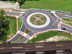
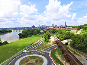
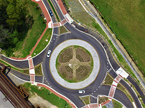
The Maury Streetscape project continues the street theme of the recently completed roundabout at the I-95 access ramps, from 5th Street west to Commerce Road, in anticipation of mixed-use and residential redevelopment. Improvements will add a 7-foot wide sidewalk on the south side of the street with an 8-foot grass buffer to the curb, where there currently are no pedestrian facilities. The existing sidewalk on the north side of the street will be repaired where damaged and new curb ramps will be added at intersections. Crosswalks will be provided on the north and south sidewalks across 5th, 6th, and 7th Streets. A raised concrete intersection is proposed for the 6th Street intersection, raising the roadway to curb height to create a visual and physical feature to slow traffic, and on the west side of 6th Street there will be a new 10’ wide crosswalk and a pushbutton-activated Pedestrian Hybrid Beacon signal designed to stop traffic for pedestrians and discourage mid-block crossings.
The project will also include street tree plantings along the south side of Maury Street, and a hardscape area at the southeast corner of the Commerce Road intersection with trees, benches, waste cans, and bicycle racks. The roadway will be resurfaced from Commerce Road to 5th Street, with signage and striping to support one eastbound lane and two westbound lanes.


PUBLIC INFORMATION
- Location: Maury Street from Commerce Road to 5th Street
- Length: Approximately 900 feet
- Purpose:
- To construct sidewalk with grass buffer along the south side of Maury Street, and install ADA-compliant ramps and crosswalks across Maury Street at Commerce Road and west 6th Street, and across the north and south sides of 5th, 6th and 7th Streets. The intersection at 6th street will be raised to curb height and a push-button controlled Pedestrian Hybrid Beacon will serve a 10’ wide crosswalk across Maury Street. Street trees, benches, bike racks and waste cans will also be included.
- Anticipated Cost*: $4,618,000
- Anticipated Schedule*:
- Right-of-Way Acquisition:
- Summer 2026 – Summer 2027
- Utility Relocation:
- Summer 2027
- Construction:
- Spring 2028 – Spring 2030
- Note:
- *The cost and schedule provided are approximate based on the current scope and design and are subject to change. The project is financed by VDOT District Grant Program including State and Federal monies.
RIGHT OF WAY
Displays show the extent of easements and right of way that may be needed as the project is currently proposed. As the design is further developed, additional easements and right of way may be required beyond what is shown on the current plans. Property owners will be informed of the exact location of the easements during the right of way acquisition process and prior to construction.
ENVIRONMENTAL REVIEW
The City of Richmond has performed environmental reviews and coordination to obtain information about environmental resources in the project vicinity; to provide natural and historic resource agencies an opportunity to review and comment on the project during its development; and to identify opportunities to avoid and minimize potential environmental impacts. In compliance with the National Environmental Policy Act (NEPA) and in coordination with the Virginia Department of Transportation (VDOT), the City of Richmond has completed a Draft Programmatic Categorical Exclusion for the project. In compliance with the National Historic Preservation Act, Section 106 and 36 CFR Part 800, information concerning the potential effects of the proposed improvements on properties listed or eligible for listing the National Register of Historic Places are included in the NEPA documentation. The NEPA document includes information from various technical reviews including those related to natural resources, water quality, threatened and endangered species, air quality and noise. The project will continue to be coordinated with the appropriate federal, state and local agencies as part of environmental review and approval processes required throughout project development and construction. All required environmental clearances and permits will be obtained prior to commencement of construction.
CIVIL RIGHTS
The City of Richmond ensures nondiscrimination in all programs and activities in accordance with Title VI and VII of the Civil Rights Act of 1964. If you need more information regarding your civil rights on this project or special assistance for persons with disabilities or limited English proficiency, contact the project manager listed
Hull Street over Manchester Canal Bridge Replacement Project
Design Public Hearing
Wednesday, March 19, 2025 from 5:00 - 7:00 pm
Main Street Station
1500 E. Main Street
Richmond, VA 23219
The City of Richmond, Department of Public Works invites you to attend a public hearing meeting at Main Street Station from 5:00 to 7:00 P.M. on March 19, 2025.
This meeting will include current plans and related documents concerning the proposed transportation improvements. The development team will be available to answer project related questions.
Project information, related documents and tentative project schedule also are available to review at 900 E. Broad Street, Rm 603; Richmond, VA 23219, 804-646-3421. Please call ahead to ensure the availability of appropriate personnel to answer your questions.
Your written or oral comments can be given at the meeting or emailed or postmarked not later than March 31, 2025 to Mr. Thomas Westbrook, Project Manager, Department of Public Works (DPW), City of Richmond, 900 East Broad Street, 6th Floor, Richmond, VA 23219. You may also email your comments to Thomas.Westbrook@rva.gov. Please include” UPC 113920 – Hull St over Manchester Canal Bridge Project” in the email subject line.
The City of Richmond ensures nondiscrimination in all programs and activities in accordance with Title VI and Title VII of the Civil Rights Act of 1964. If you need more information or special assistance for persons with disabilities or limited English proficiency, contact TTY/TDD 711.
VDOT Project No. 0360-127-035
UPC 113290
City of Richmond - Department of Public Works
Willingness to Hold a Public Meeting
Project:
Boulevard Pedestrian and Bicycle Trail from the Science Museum BRT to Scott's Addition
This project will utilize an abandoned railroad corridor to construct a paved shared use path from the Science Museum Pulse BRT Station (at the intersection of Robinson and Broad streets) to Scott’s Addition near the intersection of Patton Avenue and Altamont Avenue. The project will improve connectivity between the Pulse BRT and Scott’s Addition. It will also serve as a tie-in point for future connections to the Diamond District and Northside.
Proposed project elements include the following installations:
- A 10 foot wide concrete shared use path along Terminal Place
- A 10 foot wide asphalt shared use path from Terminal Place to the Arthur Ashe Boulevard bridge over the CSX railway, and
- Pedestrian safety improvements crossing Leigh Street
- Landscape enhancements
To review the 30 percent proposed project plans and the National Environmental Policy Act document please make an appointment to visit the Department of Public Works by calling 804-646-2467. Please call ahead to ensure the availability of appropriate personnel to answer your questions.
Comments can be mailed to Ms. Yongping Wang, Richmond Department of Public Works (DPW), 900 East Broad Street, 6th Floor, Richmond, VA 23219.
If your concerns cannot be satisfied, the City of Richmond is willing to hold a Public Hearing. Email your request with the subject, “Proposed Project: Boulevard Pedestrian and Bicycle Trail from the Science Museum BRT Pulse to Scott’s Addition” to Yongping.Wang@rva.gov or mail to the Department of Public Works.
Requests for a public hearing must be received by December 2, 2024. If it is deemed necessary to hold a public hearing, the notice of the date, time and place of the hearing will be advertised.
The City of Richmond will arrange for reasonable accommodations for non-English speaking persons or those persons with visual, hearing, or mobility impairments when notified by December 2, 2024. Please send notifications to Yongping.Wang@rva.gov or mail to DPW using the address above.
VDOT Project: 9999-127-064; UPC: 115408; Federal Project: STP-5B27(043)
City of Richmond - Department of Public Works
Project: Lombardy Street over CSX Bridge Replacement Project
Design Public Hearing
- Date: Wednesday, December 18, 2024
- Time: 5:00-7:00 p.m.
- Location: Maggie L. Walker Governor’s School, 1000 N. Lombardy Street
The Department of Public works invite you to attend a public hearing meeting at Maggie Walker Governor’s School from 5:00 to 7:00 P.M. on December 18, 2024.
This meeting will include current plans and related documents concerning the proposed transportation improvement. The development team will be available to answer project related questions.
Project information, related document and tentative project schedule also are available to review at 900 E. Broad Street, Richmond, VA 23219, 804-646-3421. Please call ahead to ensure the availability of appropriate personnel to answer your questions.
Your written or oral comments can be given at the meeting or submit them no later than January 9 2025 to Thomas Westbrook, Project Manager, Department of Public Works (DPW), City of Richmond, 900 East Broad Street, 6th Floor, Richmond, VA 23219.
- You may also email your comments to Thomas.Westbrook@rva.gov.
- Please include” UPC 104216 – Lombardy over CSX” in the email subject line.
The City of Richmond ensures nondiscrimination in all programs and activities in accordance with Title VI and Title VII of the Civil Rights Act of 1964. If you need more information or special assistance for persons with disabilities or limited English proficiency, contact TTY/TDD 711.
VDOT Project No. 0360-127-R47; UPC 104216
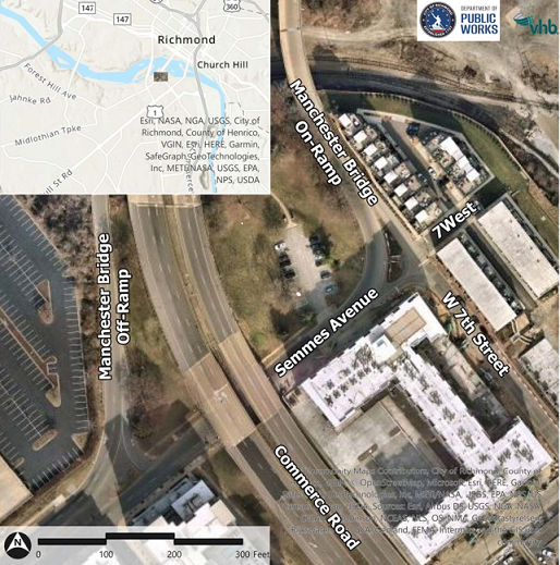
W 7th Street and Semmes Ave Improvement Survey
-
Technical Memo - W 7th Street and Semmes Avenue
- Link to Survey - CLOSED
- Proposed Long-term Concept 1
- Proposed Long-term Concept 2
- Proposed Long-term Concept 3
- Proposed Short-term Concept 4
Project Purpose: Improve safety, accessibility, and speed management for all users along the project limits.
Project Limits: Intersection of W 7th Street / Semmes Avenue / Manchester Bridge on-ramp
Introduction / Timeline: The City of Richmond Department of Public Works completed alternatives development process for the intersection of W 7th Street / Semmes Avenue / Manchester Bridge on-ramp in the Manchester neighborhood of the City of Richmond. The Department evaluated existing conditions at this location and with developing four alternative improvement concepts including one short term (Quick Build) and three long term (need Capital Improvement Fund) alternatives.
Scope of Work:
- To increase pedestrian access, improve speed management on the Semmes Avenue approach to the Manchester Bridge on-ramp, and enhance roadway visibility during darkness and inclement weather conditions.
- These objectives would be addressed in context of the City’s Vision Zero and Better Streets (complete streets) principles.
Please share this survey with others in your community. We appreciate your valuable input!
- DPW will use the comments to finalize the design and plan for each Phase.
- If you have other questions or if you need an alternate way to provide comment, please contact the project manager:
Afshin Famili, Ph.D.
Phone: 804-646‐6334
Email: Afshin.Famili@rva.gov
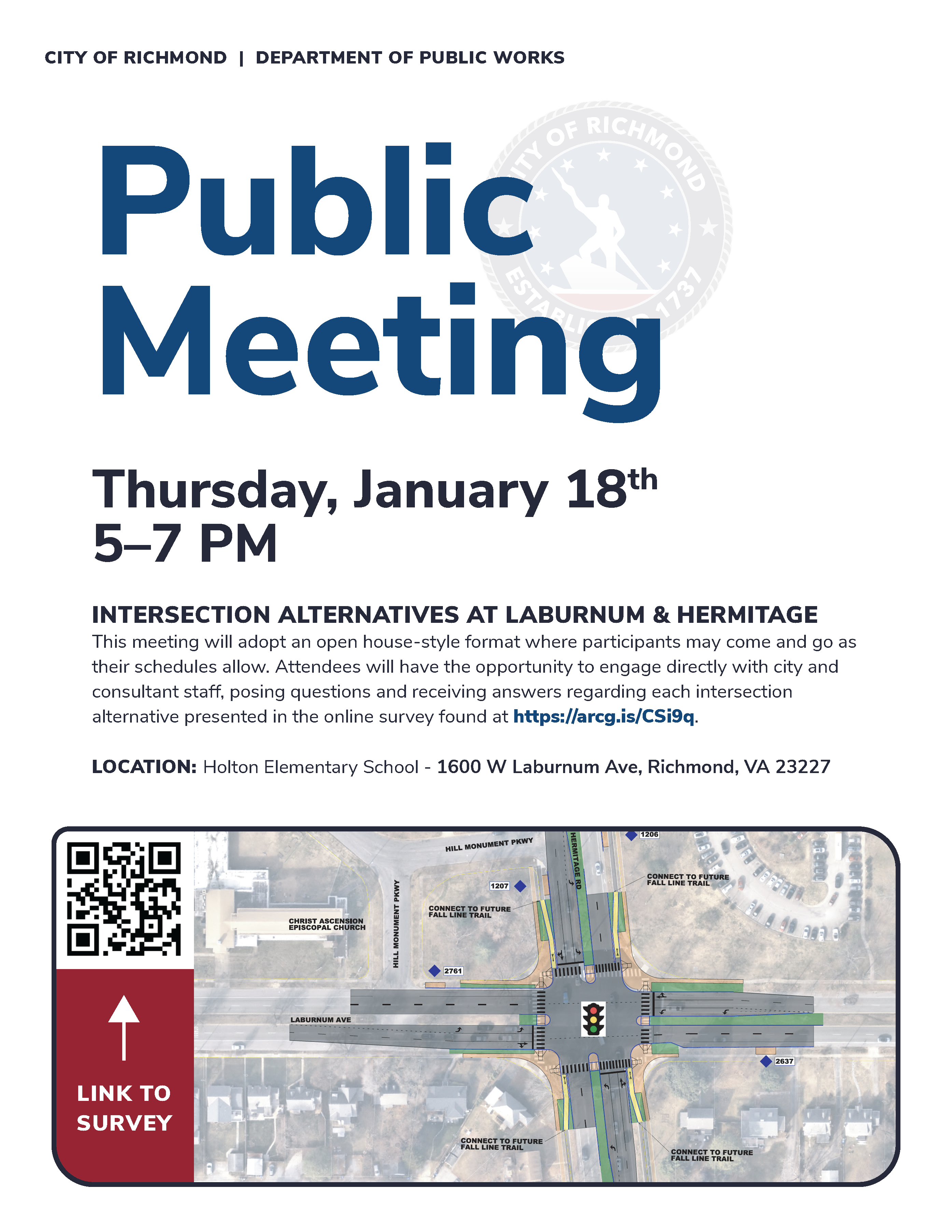
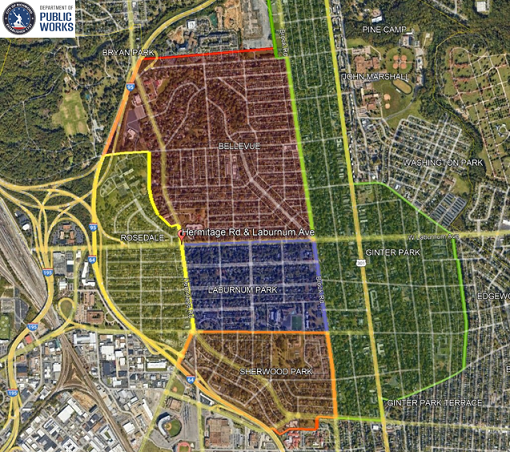
W Laburnum Ave & Hermitage Rd Intersection Survey
Public Meeting - We Need Your Input
Feedback needed for proposed improvements for the W Laburnum Avenue and Hermitage Road Project. Join us Thursday, January 18 from 5 - 7 p.m. at Linwood Holton Elementary School, located at 1600 West Laburnum Avenue (23227). Meet with staff to review and discuss options for the intersection.
-
Link to the Survey
- All Concepts
- All Concepts with Queues
- Concept 1 A
- Concept 1 B
- Concept 2 A
- Concept 2 B
- Concept 3 A
- Concept 3 B
Project Purpose:
Improve safety, accessibility, and speed management for all users through the intersection of W Laburnum Ave & Hermitage Rd
Project Limits:
Intersection of W Laburnum Ave & Hermitage Rd
Introduction: The City of Richmond’s Department of Public Works removed the A.P. Hill statue and landscaped median island in the center of the Hermitage Road and Laburnum Avenue intersection in late 2022. As a result of the removal, traffic safety has improved by removing the statuary / obstacle in the street that limited sight distance.. Traffic crashes averaged 28 crashes per year while the statue was present; the after crash trend is down 89% with a reduction to 3 crashes so far in 2023 (Figure 1). After an initial adjustment period, the City is now exploring potential intersection improvements to address accessibility and congestion.

Figure 1. Result of the removal of statuary / obstacle at the intersection.
Scope of Work:
- These objectives would be addressed in the context of the City’s Vision Zero and Better Streets (complete streets) principles.
Your thoughts on this intersection and the alternatives to be presented in this survey are welcome. Please share this survey with your neighbors and others in your community who use this intersection. Your input is valuable! If you have other questions or if you need an alternate way to provide comments, please contact the project manager:
Afshin Famili, Ph.D.
Phone: 804-646‐6334
Email: Afshin.Famili@rva.gov
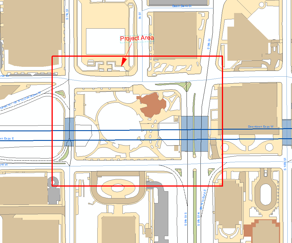
City to hold Public Meeting - May 22, 2023 for
US-60 Downtown Expressway Gateway Pedestrian Improvements Project
~ Meeting scheduled to provide information and solicit public input ~
The Department of Public Works (DPW) invites the community to attend a public meeting Monday, May 22 from 5 - 7 p.m. at Main Street Station, 1500 East Main Street to learn more about the US-60 Downtown Expressway Gateway Pedestrian Improvements Project. The project will provide improvements to the pedestrian infrastructure around Kanawha Plaza (South 9th Street, East Canal Street, South 7th Street, and East Byrd Street) in the vicinity of the downtown expressway. The proposed improvements will provide safer pedestrian access to the Plaza.
Elements of the project include:
- Increased pedestrian accessibility
- Adding and widening sidewalk
- Reconstruction of intersection geometry
- Enhanced pedestrian crossings by reducing the length of the crossing and clearly marked crosswalks
- Installation of pedestrian signals, planting street trees, and
- Installation of a new traffic signal at South 7th and East Byrd Streets
Project information will also be available at city Hall, 900 East Broad Street, 6th Floor, Richmond, VA 23219. Please call 804-646-2467 to make an appointment to review project documents. Please call ahead to ensure the availability of appropriate personnel to answer your questions.
Comments can be submitted at the meeting or mailed to Ms. Yongping Wang, Richmond Department of Public Works, 900 East Broad Street, 6th Floor, Richmond, VA 23219 or by email to Yongping.Wang@rva.gov. Please include "UPC111702 - US 60 Downtown Expressway Gateway Pedestrian Improvement Project" on the subject line. All comments must be received by the June 5, 2023 deadline.
The City of Richmond will arrange for reasonable accommodations for non-English speaking persons or those persons with visual, hearing, or mobility impairments. Please email Yongping.Wang@rva.gov or call 804-646-2467.
Willingness to hold a Public Meeting
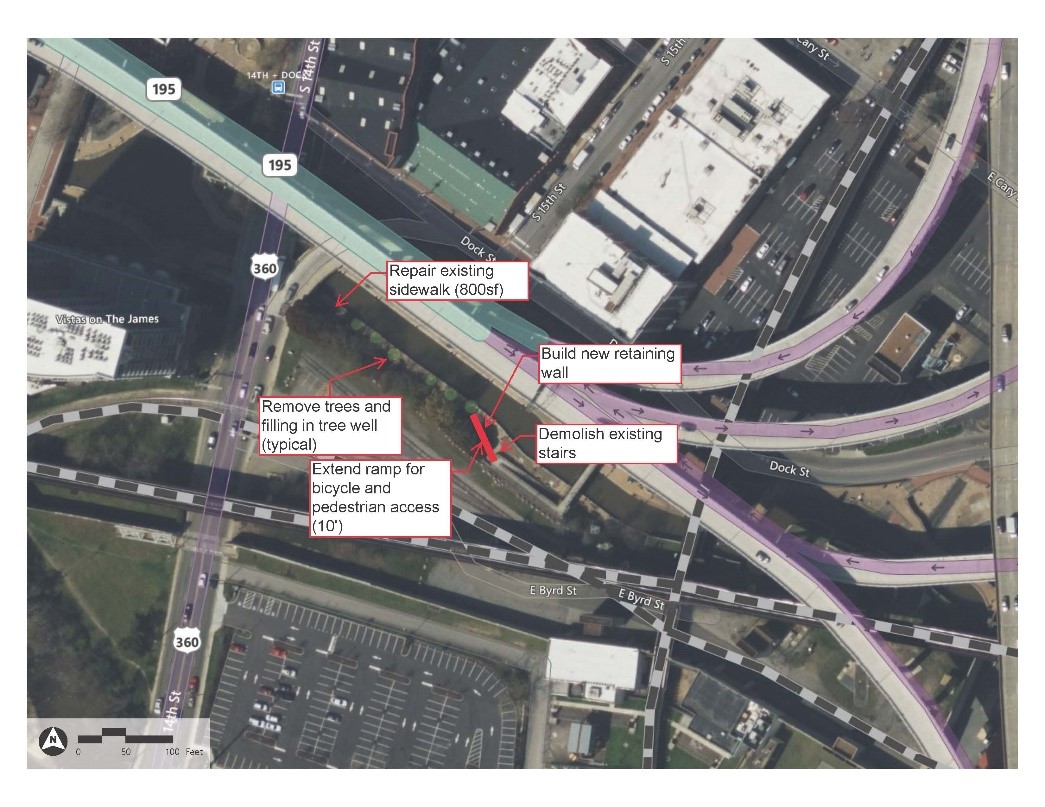
Canal Walk Improvements Project - Phase II
Comments Needed By June 16, 2023
UPC 113492 VDOT Project Number: EN19-127-040 Federal CN Number: TAP5A27 (979)
The City of Richmond has completed 30 percent design plans for the Canal Walk Improvements Project – Phase II. The project will provide improvements to the pedestrian and bicycle infrastructure along the Canal Walk in Shockoe Bottom. The proposed improvements will provide better accommodations for bicycles from the Virginia Capital Trail to Brown’s Island, and the Tyler Potterfield Bridge.
The new infrastructure will provide connectivity via the existing bridge over the Canal with modifications to improve the conditions for bicycle access, including eliminating the need for bicyclists to use the switchback, through the extension of the ramp to provide a continuous straight decent from bridge deck to Canal Walk. This will be accomplished by further eliminating the steps, retaining wall, and landscaping at the foot of the first ramp run. These modifications will provide a straight ramp to the Canal Walk.
To review project information call the City of Richmond Department of Public Works, 900 E. Broad Street, 6th Floor, tel. 804-646-6584, to request an in-person review of materials with appropriate Department of Public Works personnel to answer your questions.
If your concerns cannot be satisfied through review of the materials online or an in-person meeting, the City of Richmond is willing to hold a public hearing. You may request that a public hearing be held by sending a written request to Mr. Adel Edward at adel.edward@rva.gov Please reference “Canal Walk Improvements Project – Phase II” in the subject heading.
Comments can be mailed to Adel Edward, City of Richmond Department of Public Works, 900 E. Broad Street, 6th Floor, Richmond, VA 23219. Requests for a public hearing must be received prior to June 16, 2023. If it is deemed necessary to hold a public hearing, notice of date, time and place of the hearing will be posted.
The City of Richmond ensures nondiscrimination in all programs and activities in accordance with Title VI and Title VII of the Civil Rights Act of 1964. If you need more information or special assistance for persons with disabilities or limited English proficiency, contact TTY/TDD 711 or call Adel Edward at 804-646-6584.
Project Location
Project Design:
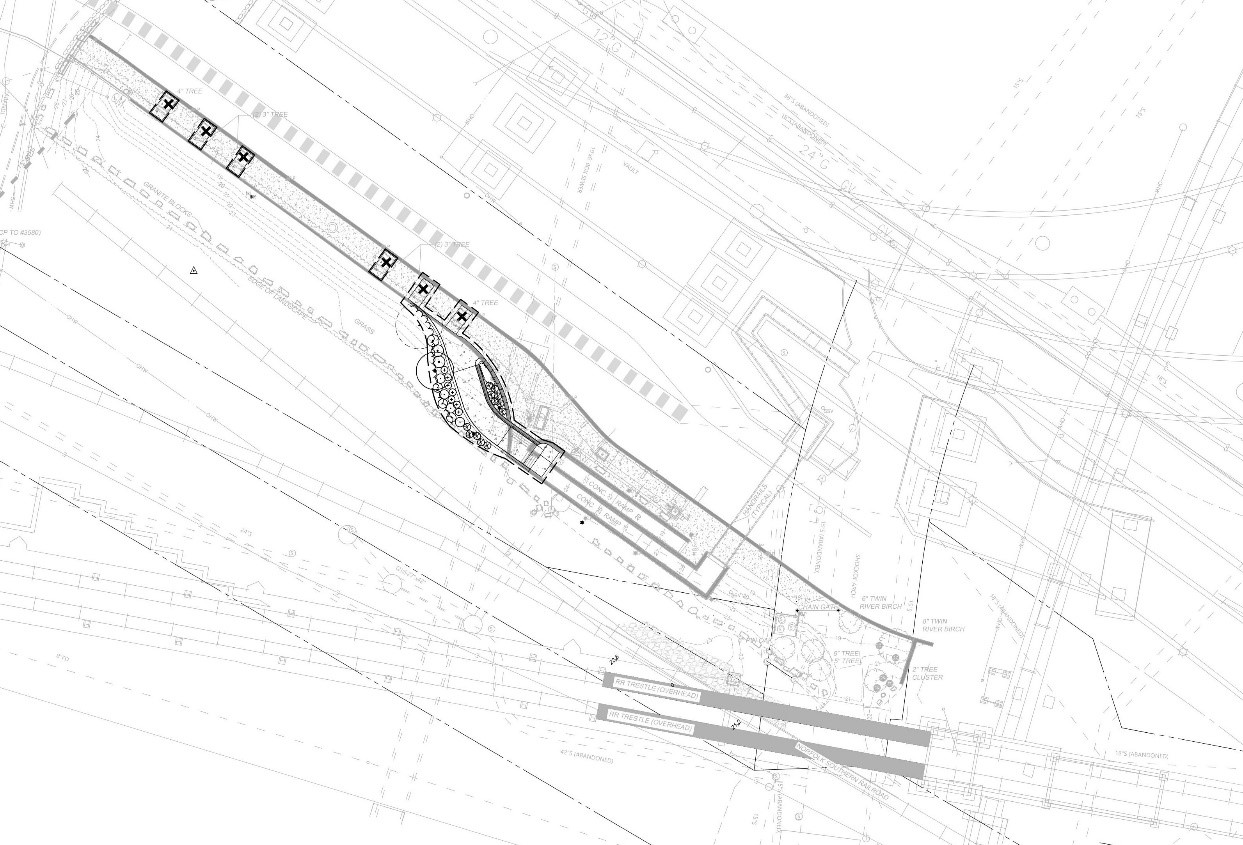
This page includes the Proposed Plans for the
(1) Hull Street Corridor Streetscape Project and
(2) Hull Street over Manchester Canal Bridge Replacement Projects
Thank You for Your Feedback - the survey period closed at 5 pm on May 12, 2022.
Survey Comments - Click here to review the comments from the survey from the Hull Street Streetscape Project.
Hull Street Corridor Streetscape Project
Projects: UPC 111703, U000-127-004, PE-101, C-501,
Federal Number: NHPP-2A27(720)
The purpose of the Hull Street Streetscape project is to enhance the overall safety and aesthetic of the Hull Street corridor in the revitalizing Manchester neighborhood. The project will improve pedestrian infrastructure and safety, improve traffic operations and safety, and provide lacking streetscape amenities.
The project will address needs related to vehicle congestion, transit amenities, missing pedestrian infrastructure, and lacking street trees and amenities. Improvements will encourage further economic investment and development in a corridor undergoing an urban revitalization.
Project Area:
- The Hull Street Streetscape project limits are from 9th Street to the Flood Wall
Improvements are limited to the existing right-of-way and generally include:
- New street trees, street furnishings (benches, bike racks, trash cans) and concrete sidewalks
- Upgraded curb ramps where nonexistent or non-compliant
- Upgrade of existing streets lights with new decorative fixtures, and installation of new decorative lights
- Minor intersection modifications at Hull St. & 2nd Street, including signal reconstruction and new phasing, crosswalks, curb extensions, new sidewalks across the adjacent Norfolk Southern railroad
- New traffic signal and crosswalks at 5th Street
- New marked crosswalks across minor intersecting streets
- New curb extension, crosswalks, southbound right-turn lane removal at Commerce Rd. intersection, and associated traffic signal modifications
- New city-owned conduit for future traffic signal fiber communications
- Modifications to existing on-street parking time restrictions
- Closure/consolidation of existing entrances to public right-of-way
Project Materials for the Hull Street Streetscape Project:
- Hull Street Streetscape Project Presentation
- Streetscape Plans
- Streetscape Plan View
- Programmatic Categorical Exclusion (PCE)
Manchester Development Area
Project Manager - Winston Phillips (email: Winston.Phillips@rva.gov)
Survey Comments - Click here to review the comments from the survey from the Hull Street Streetscape Project.
Hull Street over Manchester Canal Bridge Replacement Project
UPC 113290, 0360-127-035
Project Materials for the Manchester Canal Bridge Replacement Project:
Project Manager - Tom Westbrook (email: Thomas.Westbrook@rva.gov)
Thank You for Your Feedback
Pedestrian Safety Improvement Project
Semmes Avenue, Forest Hill Avenue and Dundee Avenue Intersections
Semmes Avenue and 34th Street Intersections
Note: The survey and comment period closed at 5 p.m. on Friday, February 18, 2022. Thank you for your feedback. The links to the documents and project information will remain online.
Click here to review the survey summary results.
History
City council passed a resolution in 2015 the study traffic calming measures at the intersection. The City hired a consultant to develop concepts solutions in 2016. Funding was approval in 2019 for project design and construction contingent on adherence to the study and concept results provided by the design team. Also in 2019 the City met with stakeholders to refine the initial selected concept. The concept was enhanced based on stakeholder input and evolved into the current safety solution.
Two Phased Project
- Provide a signal at Semmes and 34th Street. ($300,000)
- Provide enhanced traffic operations, crosswalks markings, ADA ramps and pedestrian signal. ($500,000)
These phases work together as a system, major deviation may result of forfeiture of Federal Funds and loss of project.
Total Budget & Scope
- $800,000 Design and Construction
- 80% Federal and 20% Local for design and construction 20%
- Included
- Improved Pedestrian Safety
- Signals (Traffic & Pedestrian Hybrid Beacon)
- Enhanced Crosswalks
- Upgraded ADA ramps
- Additional parking
- Additional Green Space
- Excluded
- Right of Way (land)
- Lighting
- Bike Lanes
- Included
Project Schedule (Preliminary)
- Public Engagement January/February 2022
- Advertise for Construction Summer 2024
- Start Construction Fall 2024
- End Construction Winter 2025
Project Manager: Winston Phillips email: Winston.Phillips@rva.gov or call 804-646-5994
Project Documents
- Project Presentation
- Forest Hill & Semmes Avenue Display – Aerial view
- Forest Hill Avenue Streetscape Design
- West 34th Street – Semmes Avenue Signal Plan Set
- Environmental Document PCE for UPC 113445
- Environmental Document PCE for UPC 113446
- Frequently Asked Questions
WILLINGNESS TO HOLD A PUBLIC HEARING
Find out about the proposed
- East Richmond Road over Stony Run Bridge Replacement (Project: UPC 113296; U0000-127-032) AND
- East Richmond Road over Gillies Creek Bridge Replacement (Project: UPC 113294; U0000-127-033) in the City of Richmond.
Review the project information concerning design and environmental documentation at the:
- Department of Public Works office located on the 6th floor of City Hall,
To review the above material, or for additional information, please email the Department of Public Works Thomas Westbrook at Thomas.Westbrook@richmondgov.com. Please contact Public Works ahead to ensure availability of appropriate staff to answer your questions.
If your concerns cannot be satisfied, City of
City of Richmond ensures nondiscrimination in all programs and activities in accordance with Title VI and Title VII of the Civil Rights Act of 1964. If you have questions or concerns about your civil rights in regard to this project or need special assistance for persons with disabilities or limited English proficiency, please contact the Capital Project manager noted above.
The city's infrastructure hinges on the work done by the Capital Project Division. They are responsible for new infrastructure projects, ranging from surveying and engineering design to overseeing actual physical construction. The projects cover a wide spectrum ranging from new small sidewalk projects, major sidewalk repair and curb/gutter installations to major projects such as new road construction, roadway widening and rehabilitating bridges.
The Capital Projects staff also manages state and federally funded projects within the city, such as the Belvidere and Broad Intersection Improvement Project. We also are responsible for major restoration projects resulting from damage caused by natural disasters, such as hurricanes and floods
The city of Richmond is responsible for 832 center lane miles of street, 836 miles of sidewalk, as well as 83 bridges.
Some of the many responsibilities managed by the CIP Division are:
- New Road Construction - To identify and construct new roads based on need
- Road Rehabilitation/ Modification - To identify needs and construct modifications such as realignments and widening to increase accessibility and mobility
- Bridge rehabilitation/new bridges - Rehabilitate deteriorating bridge infrastructure and construct new bridges
- Streetscape Improvements - Providing landscaping, brick sidewalk, crosswalk, streetlights and other street appurtenances
- Pedestrian / Bicycle Accessibility - To identify and correct deficiencies in the transportation network, including gaps in the infrastructure
- Traffic Calming - To construct structures to slow down traffic as needed and to increase transportation safety and promote neighborhood vitality
- Work Zone Safety - To identify, correct, and monitor improper work zones
- ADA Program - To identify and fulfill needs for handicap accessibility within the ROW
- Sidewalk Improvement Program - To identify and fulfill requests for sidewalk repairs within the ROW that are beyond the capabilities of roadway maintenance
- Neighborhood in Bloom (NIB) Program - Infrastructure improvements such as curb & gutter, sidewalk, pavement, and streetlight to compliment federal neighborhood rehabilitation funds in the six defined NIB areas.
- New Sidewalk Program - Installation of new sidewalks, prioritized based on the technical criteria.
- Urban New Curb & Gutter Program - Installation of new curb & gutter prioritized based on the technical criteria.
- Plan Review - (master plan, site plan, and design plan) To review and correct all proposed transportation plans prior to submittal and construction
- Estimating Services - Provide cost estimates for proposed Capital Improvement Projects originating from the administration, council, and the Citizens Request System.
- Grant Writing - To seek additional project funding from the state and federal government, as well as recommend expenditure of city funds. Annually, the program provides the City of Richmond with transportation improvement projects funded through the following sources:
- Transportation Alternative Federal Funds
- RSTP - Regional Surface Transportation Program
- CMAQ - Congestion Mitigation and Air Quality
- Hazard Elimination Program (Safety)
- Enhancement Grants
- Governor's Opportunity Fund
- FEMA Hazard Mitigation Grants
- VDOT Revenue Sharing
- City of Richmond Capital Improvement Program
- Private Funds
- Capital Improvements Projects
- Highway Safety Improvement Program
- Smart Scale
Major highway Capital Improvement Projects (CIP) are based on need studies that analyze technical criteria, including traffic volumes, projected growth and accident history. Some projects are developed by staff based on the mayor's goals or are a a result of City Council recommendations. While numerous other projects are based on information obtained from the RVA311 Service Request System.
CIP are primarily funded through various highway construction grants that contain federal dollars with a state match. Smaller projects utilize city funds which are backed by government obligation bonds. However, at the end of the day all funds come from taxpayers like you.
City of Richmond - Department of Public Works
Project: Broad Street over Abandoned CSX RR Spur
Design Public Hearing
- Main Street Station, 1500 East Main Street (23219)
- Tuesday, May 13 from 5 - 7 pm
The City of Richmond, Department of Public Works invites you to attend a public hearing meeting at Main Street Station from 5:00 to 7:00 P.M. on May 13st, 2025.
This meeting will include current plans and related documents concerning the proposed transportation improvements. The development team will be available to answer project related questions.
Project information, related documents and tentative project schedule also are available to review at 900 E. Broad Street, Rm 603; Richmond, VA 23219, 804-646-3421. Please call ahead to ensure the availability of appropriate personnel to answer your questions.
Your written or oral comments can be given at the meeting or emailed or postmarked no later than May 27, 2025, to Mr. Thomas Westbrook, Project Manager, Department of Public Works (DPW), City of Richmond, 900 East Broad Street, 6th Floor, Richmond, VA 23219. You may also email your comments to Thomas.Westbrook@rva.gov. Please include” UPC 118541 – Broad Street over Abandoned CSX RR Spur” in the email subject line.
The City of Richmond ensures nondiscrimination in all programs and activities in accordance with Title VI and Title VII of the Civil Rights Act of 1964. If you need more information or special assistance for persons with disabilities or limited English proficiency, contact TTY/TDD 711.
VDOT Project No. 0250-127-100
UPC 118541
Willingness to Hold a Public Hearing -
Scott's Addition BRT Streetscape
Proposed Project:
This project will address pedestrian access and safety to the Scott's Addition BRT Stations by constructing sidewalk, ADA accessible ramps and other pedestrian and streetscape amenities within the half-mile walkshed of the BRT station. The project aims to increase accessibility and improve overall pedestrian/public safety in the neighborhood.
Plan Review:
Project plans, and the National Environmental Policy Act document can be provided for review by request. Please contact Olayinka Bruce at Olayinka.Bruce@rva.gov or 804-646-2312 or call Andrew Smith at Timmons Group (804) 200-6491. Please call ahead to ensure the availability of appropriate staff to answer your questions.
Written Request:
By this notice, the City of Richmond is indicating its willingness to hold a public hearing for the project if individual concerns cannot be addressed. A request for a public hearing to be held may be made by sending a written request stating your concerns to the address below on or before June 9, 2025.
Olayinka Bruce
Richmond Department of Public Works
900 E. Broad Street, Room 603
Richmond, VA 23219
Further Notice:
If a request for a public hearing is received, and the concerns addressed in the request cannot be adequately resolved, a public hearing will be scheduled at a time and place to be advertised in a future notice.
Questions or Special Assistance:
Questions regarding this project should be directed to Olayinka Bruce using the contact information above. The City of Richmond and VDOT ensure nondiscrimination in all programs and activities in accordance with Title VI and Title VII of the Civil Rights Act of 1964. Any persons with questions on the accessibility of the facility or need reasonable accommodations should contact Olayinka Bruce at 804-646-2312.
Gillies Creek Trail - Phases II and III
Virtual Meeting Information Available November 5 - 19, 2020
The City of Richmond is currently designing a shared-use trail along Gillies Creek. The trail is intended to be located from Williamsburg Avenue to Jennie Scher Road. It is part of a larger trail network that is envisioned to connect the Virginia Capital Trail to a north side mixed-income redevelopment at Armstrong High School. The design will include safe pedestrian crossings at existing roadway intersections.
We need your input. Please review the presentation and give us your feedback. The presentation and survey will be available from November 5 – 19, 2020.
If you need additional information, please contact the project manager, Adel Edward at Adel.Edward@Richmondgov.com
NOTE: The survey period closed on Thursday, November 19. Thank you for your feedback. Thank you for your help.
Forest Hill Avenue Improvement Project
Overview
The city is currently developing construction plans for the Forest Hill Avenue Improvements project from the Powhite Parkway to Hathaway Road. The goal for the project is to provide multimodal improvements through the corridor to improve safety and enhance livability along Forest Hill Avenue.
Background
Forest Hill Avenue is an urban minor arterial road serving regional traffic and the surrounding neighborhoods and the surrounding businesses. It connects two major limited access highways, the Powhite Parkway and Chippenham Parkway and includes a significant business corridor. The busy roadway carries and average daily traffic volume in excess of 33,000 vehicles (2009) and design year traffic of 44,400 vpd (2030). Traffic projections severely impact safety and accessibility if no improvements are made. With the recommended enhancements, the new roadway will provide a safe, multi-modal corridor for all users and improve livability.
Project Manager
Alvin Hicks
Construction Inspector Supervisor
Department of Public Works
P | 804.646.5654
E | Alvin.Hicks@Richmondgov.com
Project Schedule
- Preliminary Studies/Design - Began February 2009
- Preliminary (30%) Roadway Plans - Ongoing
- Public Information Meeting #1 - December, 17, 2009
- Public Information Meeting #2 – November 10, 2010
- Public Information Meeting #3 – March 17, 2011
- Public Review of Project Documents - July 13, 2011
- City Planning Commission Conceptual Approval - July 18, 2011
- Stakeholder Meeting - September 21, 2011
- Stakeholder Meeting - October 26, 2011
- Mark Edge of Improvements, Right of Way, and Impacted Trees - Complete January 31, 2012
- Public Hearing – March 13, 2013 (Rescheduled from March 6, 2013 due to weather forecast)
- UDC Final - May 09, 2013
- CPC Final - May 20, 2013
- Right of Way Acquisition - November 2016
- Construction Advertisement - February 16, 2018
- Begin construction - August 2018
- Underground Utility Work - July - August 2019
- Roadway Work to commence - September 2019
- Phase II Utility Relocation - November 2020 - June 2021
- Final phase of construction to commence - June 2021
- Complete construction - December, 2021
Goals
The project will consider the following:
- Improving the road from four lanes to five lanes by installing a raised landscaped median for left turn lanes
- New curb
- Four foot Sidewalks
- Four foot planting strip
- Five foot Bike lanes without gutter pan
- Storm sewer system for improved drainage
- Traffic signal improvements
- GRTC bus stop enhancements
- Landscape enhancements and street lighting improvements
Funding
- Federal funds will pay for the total project estimated to cost $12 million.
- The current design phase is estimated to cost about $2 million.
- Utility relocation and right of way is estimated at $1.5 million.
- Construction will cost approximately $8.5 million.
Forest Hill Avenue Progress Plans
- Forest Hill Avenue Progress Plans - December 2016
Forest Hill Avenue Landscape Progress Plans
- Forest Hill Avenue Landscape Progress Plans - December 2016
Forest Hill Avenue Public Hearing Plans (60%)
- Forest Hill Avenue Public Hearing Plans - March 2013
Forest Hill Avenue Landscape Plans (60%)
Forest Hill Avenue Environmental Document
- Forest Hill Avenue CE Environmental Document - December 26, 2012
Design Conceptually Approved by City Planning Commission
(July 18, 2011)
- CPC Conceptually Approved Plan View - May 19, 2011
- CPC Conceptually Approved Typical Section - Informal Approval December 5, 2011
Forest Hill Stakeholder Meetings
Project Documents and Materials (As requested by citizens)
Jahnke Road Improvement Project Overview
The Jahnke Road Improvement Project is designed to improve traffic safety, improve traffic flow and enhance overall livability for the residents and users of the Jahnke Road Corridor. Jahnke Road not only carries automobile traffic, but also pedestrians, cyclists, GRTC bus riders and children who attend the three public schools located along the project corridor.
Important project elements within the design will include a shared use path, sidewalks, and landscaping. The existing roadway drainage will be upgraded from an open system with roadside ditches to a closed system with storm sewer pipe and curb and gutter which will eliminate areas slow to drain during prolonged periods of heavy rainfall.
Current funding is available for engineering, right-of-way acquisition and construction.
Project Status
Construction plans are complete and the project will be re-advertised for construction Late Spring 2023. The acquisition of right-of-way and easements for roadway construction, drainage improvements and utility relocations has concluded by the City Consultant, Stantec, for a total of 84 parcels.
Project Manager
Mr. Winston Phillips
Department of Public Works
City Hall, Suite 603
900 East Broad Street
Richmond, Virginia 23219
E | winston.phillips@rva.gov
Jahnke Road Design Elements
- Raised 16-ft landscaped median separating two travel lanes (one lane in each direction)
- New curb and gutter
- New storm sewer system
- Left turn lanes are provided at Newell Road, Spruance Road, Forestview School Drive (entrance to Elizabeth Redd Elementary School), Irby Drive and Leicester Road
- 5-ft sidewalk with a 6-ft green space for landscaping on the south side of Jahnke Road
- 8-ft shared use path with a 8-ft green space for landscaping on the north side of Jahnke Road
- ADA (American with Disabilities Act) compliant for pedestrian traffic and bus commuters
- New Signal at Forestview School Drive (entrance to Elizabeth Redd Elementary School)
- Safety improvements at CSX rail crossing
Estimated Costs
- Preliminary Engineering Costs: $2,940,000
- Utility and Right of Way Costs: $3,300,000
- Roadway Construction Costs: $33,600,000
- Total Estimated Costs: $39,840,000
- The project is funded with Federal, State, and City funds.
Project Plans
Milestones
- Re-Advertise for Construction - Late Spring 2024
- Construction Awarded - Winter 2025
- Complete Construction - Spring 2028
Expenses (costs are reported quarterly)
- Life to date: $6,625,000
Project Overall Status (Active, Pending or Complete)
- Active-Utility relocations and adjustments are ongoing
Plans
Anticipated Project Construction Schedule
-
Right of Way Acquisition complete (84 parcels)
-
Utility Coordination/Relocation - Complete
-
Re-Advertisement for Construction Late Fall 2025
-
Complete Construction Spring 2028
Previous Project Milestones
- Began Right of Way Acquisition – Spring 2013
- Right of Way Acquisition - November 2016
Jefferson Avenue Project Overview
This project builds on the EPA project, the Greening of Jefferson Avenue, from December 2015. The City of Richmond allocated $500,000 in FY2019 from the Capital Improvement Program (CIP) to the Department of Public Works, which includes survey, conceptual design of the entire corridor, public meetings, and phase I & Phase II design of landscape/streetscape, multimodal transportation, and integrated stormwater. Phase 1 (Area 1) is south side of intersection at Jefferson Ave. /Leigh St./ 24th St., which was completed in Summer 2020. Phase II (Area 2, 3,4) is on Jefferson Ave. from Leigh St. to M St./25th St.. Construction of Phase II will start in Summer 2024. Phase III from Clay St. to Leigh Street will start design in Summer 2025. Design of Phase IV and construction of phases III & IV will depend on future funding availability.
This project will improve the Jefferson Avenue Corridor to promote economic activity through the inclusion of pedestrian safety, bicycle accommodations, additional greenspace, improved transit access, and stormwater runoff reduction. Ultimately, this “complete streets” approach to the project seeks to create a more livable Jefferson Avenue and further establish the Corridor as the gateway to Union Hill and Church Hill.
Total Project Cost: $5,200,000
Scope: Sidewalks, curb extensions, handicap ramps, bike racks, landscaping, and drainage improvements
| Phase | Limits | Cost | Status |
|---|---|---|---|
| Phase I | Intersection of Jefferson & leigh & 24th (Previously Area 1) | $600,000 | Completed 2020 |
| Phase II | Leigh to 25th (Previously Area 2, 3, 4) | $1,200,000 | Construction begins Summer 2024 (FY25 Funding) |
| Phase III | Clay to Leigh | $2,200,000 | * Anticipated Construction in Summer 2026 (FY27 RSP) |
| Phase IV | Marshall to Clay | $1,200,000 | TBD (base on future funding) |
* Construction of Phase III depends on the approval of FY25-26 VDOT Revenue Sharing Program (RSP) funding application. Funds will be available in FY27 & FY28.
Project Budget (Approved FY24-28 CIP Budget)
| FY24 | FY25 | FY26 | Total | GO Bond Funds for Existing RSP 50% Match | Remaining GO Bonds Funds for FY27-28 VDOT RSP Cycle 50% Match | |
|---|---|---|---|---|---|---|
| GO Bond | $200,000 | $1,300,000 | $293,500 | $1,793,500 | $698,000 | $1,095,500 |
| Revenue Sharing | $352,000 | $346,000 | $698,000 | |||
| Total: | $2,491,500 |
Project Manager
Ms. Yongping Wang, Principal Engineer
City of Richmond
Department of Public Works
City Hall, Suite 603
900 East Broad Street
Richmond, Virginia 23219
P | 804.646.2467
E | yongping.wang@richmondgov.com
Design Goals
The goal of this project is to reinvent Jefferson Avenue as a street that meets the needs of the citizens of Church Hill and Union Hill, as well as all users of the corridor. To that end, Timmons Group has advanced the conceptual designs, which focus primarily on (1) traffic calming through speed tables, enhanced traffic circles, and narrowed lanes, (2) pedestrian accommodations through bump outs for shorter crossings and improved ADA compliance, and (3) increased greenspace through reclaiming asphalt areas to reduce storm water runoff. The concept has benefits that impact the Jefferson Avenue corridor in several ways, such as pedestrian safety and drainage improvements, with the goal to create a more livable neighborhood. This project will improve the Jefferson Avenue corridor to promote economic activity through the inclusion of pedestrian safety. The project is in a corridor that successfully mixes locally-owned business and residential neighborhoods. The vision for the streetscape improvements was to improve the experience of all users.
- Finalizing the design of Phase II (Area 2,3,4) in Winter, 2023;
- Preparing Bids of Phase II in Spring, 2024
- Start construction of Phase II in Summer 2024
- Start design of Phase III ( Clay to Leigh St.) in Summer 2025
Biotech Phase III – Leigh Street Streetscape Project
The City is currently developing construction plans for the Biotech Phase II -Leigh Street Streetscape project. The project proposes roadway improvements on E. Leigh Street starting at the intersection of N. 4th Street and extending approximately 3,300 feet to the east, to the western edge of the Martin Luther King Bridge, just east of 12th Street. The project will provide signal improvements at the intersections; sidewalk installation; shared use path (SUP) for bicycle and pedestrian, and streetscape throughout the project limits.
Project Manager
Ms. Yongping Wang, Principal Engineer
City of Richmond
Department of Public Works
City Hall, Suite 603
900 East Broad Street
Richmond, Virginia 23219
P | 804.646.2467
E |yongping.wang@RVA.GOV
Estimated Costs
- Preliminary Engineering Costs: $780,000
- Utility and Right of Way Costs: $523,000
- Roadway and Construction Costs: $$5,800,000
- Total Estimated Costs: $7,103,000
The Project is funded with Federal funds.
Project Plans
- Leigh Street Streetscape - %60 plans - Plans can be viewed at City Hall (900 E Broad St) as requested.
- Leigh Street Streetscape Design Concept Boards
- Anticipated Project Construction starts in Summer 2025