
Dironna Moore Clarke
Deputy Director, Department of Public Works
Address:
1500 E Franklin St
Richmond, VA
23219 USA
Hours: Mon - Fri (8 a.m. - 5 p.m.)
Phone No. 804-646-6430
Email: Ask Public Works
Franklin Street Safety and Mobility Improvement Project
Thank you for taking time to provide us with your feedback for this project.
The survey was closed on September 24, 2023.
Survey results have been compiled and a summary report developed - Survey Results Summary
Link to Survey
The City of Richmond Department of Public Works needs your input on proposed conceptual designs for the Franklin Street Safety and Mobility Improvement Project along West Franklin Street from Lombardy Street to Belvidere Street.
The project will connect to the existing two-way cycle track along Franklin Street from Belvidere Street to 9th Street. Feedback from the survey will be used to help guide design implementation and finalize plans.
The proposed design includes:
- Implementing a roadway conversion within the existing roadway cross-section to improve accessibility and safety for bicyclists by incorporating a two-way “cycle track” bicycle lane
- Using the existing roadway width to either replace one vehicle travel lane, or reduce existing travel lane widths to accommodate the bicycle infrastructure
Let Your Voice Be Heard! Please review the conceptual designs and complete the survey by Sunday, September 24.
For more details or assistance with alternative means to review and comment, email the Project Manager at Afshin.Famili@rva.gov or call 804-646-6334.
Update posted 7-2-24
Press Release with project update.
Proposed SR 161 Bike Lane Projects | Online Survey Closed June 1, 2023
The 2nd round survey will be available May 11 - June 1, 2023
NEW Renderings and Information for Round 2:
The Department of Public Works (DPW) invites the public to learn about the State Route 161 (SR 161) bike lane project via two phases north and south of the James River.
Project Purpose: Improve safety, accessibility, and connectivity along this urban corridor.
History / Timeline: Department of Public Works initiated a project several years ago to design bike infrastructure on Westover Hills Blvd (state route 161) between Forest Hill Ave and Riverside Drive (on the approach to the "Nickel" Bridge). One of the primary comments from the public at the time was that the project was too limited in scope, and that bike infrastructure needed to extend beyond those limits. DPW secured additional funding from the Federal Transportation Alternatives Program to extend the design south of Forest Hill Ave, as well as designing bike lanes on SR 161 (Park Drive and Blanton Ave) north of the James River. Detailed design planned for 2023. Implementation planned for 2024.
Scope of Work:
- PHASE I: Roadway bicycle improvements on Westover Hills Boulevard (SR 161) beginning just south of the Boulevard Toll Bridge and running south to the intersection with Dunston Avenue / 49th Street.
- This segment/phase will also propose pedestrian and bicycle improvements along 49th Street beginning at the Duston Avenue/Westover Hills Boulevard intersection and running south to the cul-de-sac at the Hill Top Drive intersection.
- PDF with Phase Renderings
- Renderings from the initial survey (it was open Feb 9 - 28, 2023)
- PHASE II: On-roadway bicycle improvements along Park Drive and Blanton Avenue (SR 161) beginning at Pump House Drive and running north to the French Street intersection.
- This phase will also include Improved pedestrian crossings at the intersection of Blanton Ave and Park Drive.
- PDF with Phase II Renderings
- Renderings from the initial survey (it was open Feb 9 - 28, 2028)
Please share this survey (link listed above) with others in your community. We appreciate your valuable input!
- DPW will use the comments to finalize the design and plan for each Phase.
- If you have other questions or if you need an alternate way to provide comment, please contact the project manager
Project Manager: Afshin Famili, Ph.D.
- Office: 804-646‐6334, or
- Email: Afshin.Famili@rva.gov
We’re Social! For updates on DPW-related projects, activities and events visit us on Twitter @DPW_RichmondVA
Thank You for Participating !
Virtual Public Engagement - Proposed Bike Lanes
The Survey Closed on September 26, 2022
The Department of Public Works (DPW) invited the public to learn about bike lane projects under consideration as part of DPW’s paving and resurfacing program for summer 2022 through summer 2023. The projects support the City’s Vision Zero Action Plan by using our Better Streets multimodal approach to improve safety for all roadway users. The corridors under consideration are:
- Admiral Street/School Street – from Lombardy Street to Chamberlayne Ave
- German School Road – from Glenway Drive to Midlothian Turnpike
- North Sheppard Street – from Broad Street to Clay Street
- Norfolk Street – from Arthur Ashe Boulevard to Belleville Street
- West Marshall Street – from Arthur Ashe Boulevard to Roseneath Road
- West Moore Street – from Arthur Ashe Boulevard to Belleville Street
- Warwick Road – from Hull Street Road to Brookline Street
The Department is also proceeding with bike infrastructure on the northside and southside along State Route 161 which includes the following city streets:
- 49th Street – from Hill Top Drive to Clarence Street
- Westover Hills Boulevard – from Clarence Street to Riverside Drive
- Park Drive – from Pump House Drive to Blanton Avenue
- Blanton Avenue – from Park Drive to French Street
There will be a separate survey (at a later date) for the four (4) streets, listed above, along State Route 161.
If you have any questions or need assistance with alternative means to review and comment, contact Jakob Helmboldt at 804-646-7141 or Jakob.helmboldt@rva.gov
For more information on the Department of Public Works, please visit us online at www.rva.gov/public-works or send email questions to AskPublicWorks@rva.gov
We’re Social! For updates on DPW-related projects, activities and events visit us on Twitter @DPW_RichmondVA
As the City continues pressing forward to make Richmond more bike friendly, several projects comprising over 60 miles of separated bike infrastructure have been completed:
- 1st Street – Duval Street to Franklin Street
- 2nd Street from Spring Street to US Route 1
- 3rd Street – Broad Street to Franklin Street
- 17th Street - Dock Street to Franklin Street
- 29th Street – Fairfield Avenue to Libby Hill Park
- Bank Street / Franklin Street – 12th Street to 18th Street
- Broad Rock Road – South City Limits to Hull Street
- Brook Road – Azalea Avenue to Charity Street
- Brookland Parkway – Arthur Ashe Boulevard to Brook Road
- Cannon Creek Greenway – Valley Road to Craigie Avenue
- Dock Street - Pear Street to Main Street
- Fairfield Way – Oliver Hill Way to Mechanicsville Turnpike
- Floyd Avenue - Thompson Street to Laurel Street
- Forest Hill Avenue - Powhite Parkway to Hathaway Road
- Franklin Street - Belvidere Street to 9th Street
- German School Road – Jahnke Road to Warwick Road
- Government Road - Williamsburg Road to Glenwood Avenue
- Grayland Avenue - Addison Street to Harrison Street
- Hermitage Road – North City Limits to Brookland Parkway
- Hioaks Road – Jahnke Road to Carnation Street
- Hospital Street – 5th Street to Valley Road
- Jahnke Road – Hioaks Road to Blakemore Road
- Leigh Street - Dinneen Street to Myers Street
- Lombardy Street - Broad Street to Brook Road
- Main Street - Williamsburg Road to Nicholson Street
- Malvern Avenue - Fitzhugh Avenue to Cary Street
- Manchester Bridge
- Marshall Street - 21st Street to 29th Street
- MLK Bridge
- Mosby Street from MLK Bridge to Fairmount Avenue
- Nine Mile Road - 25th Street to I-64
- North Avenue - Laburnum Avenue to Chamberlayne Avenue
- Patterson Avenue – Thompson Street to Commonwealth Avenue
- Roanoke Street - Midlothian Turnpike to Forest Hill Avenue
- Semmes Avenue - Forest Hill Avenue to Cowardin Avenue
- Tyler Potterfield Bridge
- Virginia Capital Trail from Flood Wall to East City Limits
- Warwick Road from Hull Street to Richmond Highway
- Williamsburg Avenue from Northampton Street to Nicholson Street
- US Route 1 Bridge
Navigate greater Richmond by bike using our region's existing on-street bikeways and paved multi-use trails.
Have an update for the map? Email louise@sportsbackers.org at Bike Walk RVA.
- 49th Street – Westover Hills Boulevard to James River Branch Railroad
- Blanton Avenue – Park Drive to French Street
- Canal Walk Connector – Flood Wall to Brown’s Island
- Fall Line Trail – Manchester Bridge to Byrd Street
- Fall Line Trail – Commerce Road – Manchester Bridge to Decatur Street
- Fall Line Trail – Commerce Road – Decatur Street to Southern Connection
- Fall Line Trail – Southern Connection from Commerce Road to Chesterfield County
- Gillies Creek Greenway - Williamsburg Avenue to Jennie Scher Road
- Hopkins Road - Holly Springs to Walmsley Boulevard
- Hull Street – Arizona Drive to Chippenham Parkway
- James River Branch Trail – Hopkins Road to 49th Street
- Leigh Street – 8th Street to MLK Bridge
- Lombardy Street Bridge
- Mosby Street – Venable Street to MLK Bridge
- Oliver Hill Way – Hospital Street to Grace Street
- Park Drive – Boulevard Bridge to Blanton Avenue
- Walmsley Boulevard – West City Limits to Belmont Road
- Westover Hills Boulevard - Boulevard Bridge to Forest Hill Avenue
- 2nd Street – Spring Street to Byrd Street
- 3rd Street – Franklin Street to Byrd Street
- Admiral Street - Lombardy Street to Brook Road
- Allen Avenue - Colorado Avenue to Leigh Street
- Belmont Road - Chesterfield County Line to Walmsley Boulevard
- Broad Rock Road – Hull Street to Forest Hill Avenue / Bainbridge Street
- Byrd Street – 2nd Street to 3rd Street
- Carnation Street - Hioaks Road and Midlothian Turnpike
- Colorado Avenue - Hampton Street to Dance Street
- Fairfield Avenue - 26th Street to Cool Lane
- Fairmount Avenue - Mosby Street to 25th Street
- Forest Hill Avenue - 41st Street to Dorchester Road
- Government Road – Glenwood Ave to Broad Street
- Holly Springs Avenue - Hopkins Road to Broad Rock Road
- Jahnke Road - Blakemore Road to Forest Hill Avenue
- Magnolia Street - 1st Avenue to Rady Street
- Marshall Street – Arthur Ashe Boulevard to Roseneath Road
- Moore Street – Arthur Ashe Boulevard to Belleville Street
- Norfolk Street – Arthur Ashe Boulevard to Belleville Street
- Rowen Avenue - Trigg Street to 5th Street Bridge
- School Street - Lombardy Street to Chamberlayne Avenue
- Sheppard Street – Broad Street to Clay Street
- Warwick Road – Hull Street Road to Midlothian Turnpike
- Williamsburg Avenue - Main Street to Nicholson Street
The current bike master plan is incorporated as a part of the broader Richmond Connects Strategic Plan. The process of creating this plan and choosing these projects can be found at rvaconnects.com and the bicycle component of the plan itself can be found at the link below.
StrategicPlan_240209_reduced_FINAL_webfinal.pdf (rva.gov)
The previous bicycle master plan and corridor inventory can be found here:
Richmond Bicycle Master Plan
Appendix E – Corridor Inventory
Note: if you are using Google Chrome as your browser, the PDF documents may initially display with an unreadable font. If this occurs, reload the page (using the circular arrow on the browser bar) and the document should display properly.
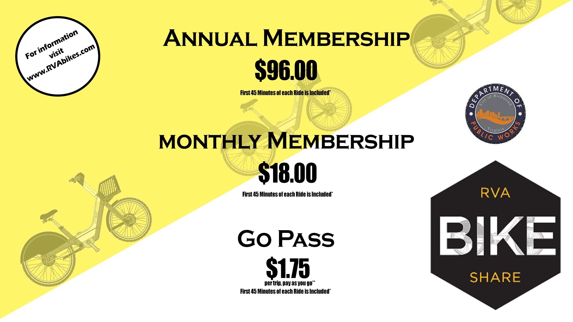
RVA Bike Share Program
-
Inaugural deployment of 200 bikes and docking stations took place in summer 2017.
- Additional bikes and stations are on order, as are upgrades for our existing fleet to convert them to electric assist.
- Conducting site review and pre-planning for additional stations and electrical connections
- Drop Mobility is handling the RVA Bike Share operations. Please contact them at info@rvabikes.com
- Bike Share User Agreement
RVA Bike Share - How it Works
To download the application, get pricing, sponsorship information, checkout a bike or see a map, go to the RVABikeShare application.
For more information on RVA Bike Share visit: www.RVAbikes.com
Parking
Floating Parking
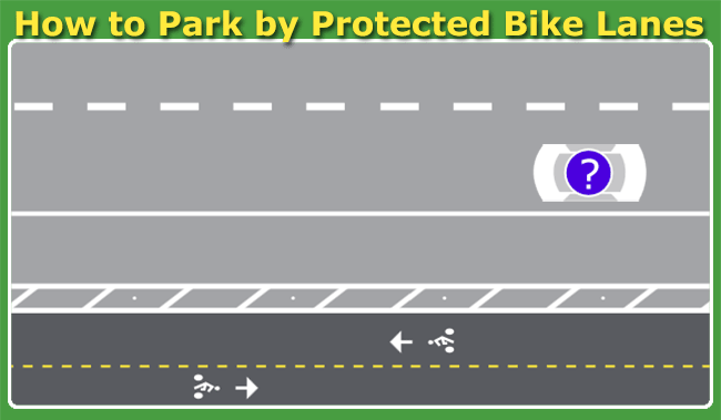
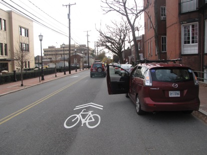
“Floating Parking” will be seen more and more on streets throughout Richmond as more bike lane projects are striped. One of the first areas you’ll see it is on Franklin Street. This parking arrangement allows for bike lanes to be located along the curb, with parked cars providing a degree of separation from the moving traffic. Though it will look different, parking in a floating lane is essentially the same as a typical curbside lane. Just follow a few basic rules:
- Don’t park in the bike lane.
- Park next to the buffer, not in it. Treat the buffer like the curb. This will give you space to get in and out of your vehicle without being in the bike lane.
- Look for cyclists while crossing the bike lane when getting in or out of your vehicle.
- If a peak hour (“rush hour”) or time limit restriction is in place, it will be posted on the sidewalk, the same as traditional parking lanes.
- On Franklin Street during the morning peak (7AM-9AM) the floating parking lane next to the bike lane buffer will be open to traffic. The remainder of the day it will serve as a parking lane.
- Anticipate 2-4 weeks for new traffic patterns and for drivers to adjust to the new lane configurations.
Here is some guidance to help you better understand:
{"preview_thumbnail":"/sites/default/files/styles/video_embed_wysiwyg_preview/public/video_thumbnails/20302720.jpg?itok=JXCUntKO","video_url":"https://vimeo.com/20302720","settings":{"responsive":1,"width":"854","height":"480","autoplay":1},"settings_summary":["Embedded Video (Responsive, autoplaying)."]}
Bike Parking in Richmond
Locking tips
Avoid common mistakes to reduce the chance that someone can steal your bike.
- Always lock to the bike frame, not just the wheel.
- Never lock around the fork leg. Someone can remove the front wheel and slide the fork out of the lock, and take your entire bike.
- Use a strong lock such as a U-lock and/or a chain or cable lock made specifically for bikes since they are hard to cut.
- Quick release wheels can be stolen in seconds. Consider locking your wheels as well as your frame.
Locking laws
The City is in the process of installing bike parking racks throughout Richmond, but there will always be places that lack a bike rack. Be mindful of how and where you park your bike. The City has several provisions aimed at keeping our sidewalks clear and free of clutter.
- Never lock to a tree, your bike can be impounded. Street trees are especially susceptible to damage from gouging or chaffing of the bark which can result in the tree becoming diseased or dying. Plus, our trees are for beautification, not parking.
- Bikes that are deemed inoperable due to missing parts or significant damage can be impounded after three days if locked to City property (e.g. signs, bike racks, etc).
- Bikes that are locked to city property for more than ten consecutive days (without being moved during that period) can be deemed to be abandoned and impounded.
- Impounded bikes are held for a period of at least 30 days, after which time they may be sold or donated to a non-profit organization.
{"preview_thumbnail":"/sites/default/files/styles/video_embed_wysiwyg_preview/public/video_thumbnails/oJxcQOL96yI.jpg?itok=ea2D_2ln","video_url":"https://www.youtube.com/watch?v=oJxcQOL96yI","settings":{"responsive":1,"width":"854","height":"480","autoplay":1},"settings_summary":["Embedded Video (Responsive, autoplaying)."]}
Bicycling, walking, and using transit are safe, efficient and healthy ways of getting around the city, but there are laws and safety tips to be mindful of. People who drive, bike or walk have shared rights and responsibilities and a little courtesy goes a long way towards making our city safer and more pleasant to get around.
- Remember that all drivers are required to share the public city street and this can be a complex environment. It is best to slow down below the posted speed limit.
- Remember that every intersection is a crosswalk. Always stop for people walking, rolling, or riding a bike in the crosswalk, whether marked or unmarked, and yield to people crossing the street when turning (right or left).
- Unmarked crosswalks carry the same stopping requirements as do marked crosswalks.
- Unmarked crosswalks exist at almost any intersection within the City. It is where sidewalks, if available, lead to the intersection; if there are no sidewalks, an unmarked crosswalk still exists at the intersection if the speed limit is 35 MPH or lower.
- Stop for people walking, rolling, or riding a bike on the sidewalk when entering or departing the street at alleys, driveways, and commercial entrances.
- When passing a person on a bike, allow at least three feet (3’) of clearance, and drive at a safe speed. If the lane is not wide enough to pass with the required three-foot (3’) clearance, you are required to change lanes.
- When parking on-street, look for persons riding bicycles before opening your door. A good practice is the “Richmond Reach”, where you open your door using your opposite (right) hand, as it allows you to look over your shoulder for persons riding bicycles.
- It is a Class I Misdemeanor to cause bodily injury to a person walking, rolling, or riding a bicycle on City streets, punishable by up to 12 months in jail or a fine up to $2,500 or both.
- Always ride in the same direction as traffic, unless riding in a contra-flow lane or two-way cycletrack, as indicated by official pavement markings and signage.
- Riding side by side in a travel lane is allowed.
- A front light and rear reflector are required after dark. On roads with posted speeds of 35 MPH or greater, a red taillight is also required. A taillight is strongly recommended any time after dark.
- When riding in a lane shared with motor vehicles, ride as far to the right as safely practicable, and “take the lane” when appropriate. See the “Taking the Lane” section below for more details.
- Use proper hand signals when turning or changing lanes.
- When riding in the street, you should use the same lane as you would be if you were driving a motor vehicle. Use right and left turn lanes, and proceed straight through an intersection from a through lane, not a turn lane.
- Riding on the sidewalk is legal, but you must yield to a person walking or using a mobility device. (See the “Riding a Bicycle on the Sidewalk” section for more details.) When crossing the street, a person on a bicycle or scooter has the same rights and responsibilities as a person walking.
- Always stop for persons walking or using a mobility device when you are obligated to, such as at a marked or unmarked crosswalk (see the “When Driving a Vehicle” section above for more details), and announce when you are passing from behind if on a sidewalk or shared use path.
- Helmets are not required by law, but they are recommended and may help protect you in the event of a crash or fall.
- While the City no longer requires bike registration, you are highly encouraged to register your bike with the National Bike Registry. Keep a record of your serial number and any identifiable features, as this will aid with finding the owner of a recovered bike following a theft or loss.
- A front light and rear reflector are required after dark, and a rear taillight is required when riding on a road with a speed limit of 35 MPH or higher. A headlight and taillight are also recommended during low-visibility conditions, such as when it’s raining, and when used during the day, increase your conspicuity.
- Use white lights on the front and red lights on the rear of your bicycle, as it helps other roadway users determine which direction you are riding.
- Reflective material on your legs or feet is more noticeable since they are in motion. A pants strap with reflective material serves a dual purpose.
Riding a bicycle or scooter on the sidewalk is a major contributor to crashes and can create conflicts with persons walking or using a mobility device. See the “Riding a Bicycle on the Sidewalk” section above for more details.
- Riding a bicycle on the sidewalk is a major contributor to bike crashes and can create conflicts with persons walking or using a mobility device.
- Always yield to people walking when riding on the sidewalk.
- Ride at a slow speed and watch for people coming out of doorways or around corners of buildings.
- Driveways and alleys present blind areas where a person driving can’t see a person on a bike approaching, especially if riding on the sidewalk.
- People driving often aren’t looking for, or expecting, a person on a bicycle riding on a sidewalk or through a crosswalk.
- Biking on a sidewalk against traffic also violates expectations of where a person a bike will be encountered.
- A person bicycling on a sidewalk adjacent to parked vehicles may not be visible to a person driving, especially when turning left or right at an intersection.
- It is a Class I Misdemeanor to cause bodily injury to a person walking on city streets, punishable by up to 12 months in jail or a fine up to $2,500 or both.
In an urban environment, it is often legal and actually safer to “take the lane”, positioning yourself towards the middle of the travel lane. You are more visible when positioned in the travel lane and not weaving in and out of traffic. You also avoid the parked car “door zone” where an opening door can cause a crash or a swerve into traffic.
State law specifically notes the following conditions when a person on a bicycle or scooter is encouraged to ride away from the right curb or edge of the roadway:
- When overtaking and passing another vehicle proceeding in the same direction;
- When preparing for a left turn at an intersection or into a private road or driveway;
- When necessary to avoid conditions including, fixed or moving objects, parked or moving vehicles, pedestrians, animals, surface hazards, or substandard width lanes (where it is too narrow for a bicycle and another vehicle to pass safely side-by-side);
- When avoiding a lane that must turn or diverge to the right; and
- When riding upon a one-way road, where you may ride as near the left-hand curb or edge as safely practicable.
Sharrows are placed in the lane specifically to improve rider positioning and to communicate to persons driving that they must share the road with persons on bicycles and scooter.
- Whenever possible, cross at an intersection and use the crosswalk.
- At a traffic signal or pedestrian hybrid beacon, follow the “walk” and “don’t walk” signals.
- Sometimes sidewalks are not available or accessible, making walking or rolling in the roadway necessary. Always travel facing traffic when in the roadway. It is the law and is much safer.
- Unmarked crosswalks exist at almost any intersection within the City. It is where sidewalks lead to the intersection; if there are no sidewalks, an unmarked crosswalk still exists at the intersection if the speed limit is 35 MPH or lower.
- Communicate your intentions to cross the street. A person driving a car will be more likely to stop if you give them visual cues: eye contact, moving off the curb, or even a wave or hand motion.
- Lights and/or reflective material are a good idea if traveling at night. Streetlights can cast shadows and glare. Don’t assume you can be easily seen at night.
- Alcohol and drug use as well as other impairments (e.g. distractions or drowsy) are a major contributor to crashes with people walking.
 Frequently Asked Questions
Q: What are the bike symbols that are on some city streets?
Q: Is that a bike lane?
Q: What am I supposed to do as a driver?
A: They are not bike lanes, but rather shared lane markings, or sharrows which are used on streets with bike activity but where there is not enough roadway space for a separate bike lane. It reminds motorists that they will likely encounter bicyclists sharing the travel lane.
Q: I’ve heard I’m supposed to have a registration for my bike, is that true?
A: The City no longer requires bike registration. However, we encourage people to register their bikes with the National Bike Registry. This will aid police in identifying the owner of a bike that is recovered following a theft.
Q: Am I allowed to lock my bike to city property such as signposts and trees?
A: Please see the bike parking guide on this website for details on local regulations Bike Parking Guide. City trees are the only item that is specifically prohibited, and a bike locked to a tree can be impounded.
Q: Isn’t it safer for a bicyclist to ride facing traffic so they can see cars approaching them?
A: Riding against traffic is a leading cause of crashes between bicyclists and motorists. For this reason it is also illegal. Bicyclists should always ride in the same direction of traffic when on the roadway.
Q: Is it illegal to ride my bike on the sidewalk?
A: The City of Richmond does not have a local ordinance prohibiting bicycling on sidewalks. BUT, if riding on a sidewalk you must yield to pedestrians, and should ride slowly. Colliding with motorists at intersections is a leading cause of crashes because motorists aren’t expecting a bike entering the crosswalk at high speed, especially when travelling against traffic.