

Address: 900 E. Broad St.,
Room 115
Richmond, VA 23219
Phone: (804) 646-4646
For gas leaks, leave the area and call 911
Follow us on our social media channels for news and updates:![]()
![]()
![]()
![]()
For other news, check out our news page:
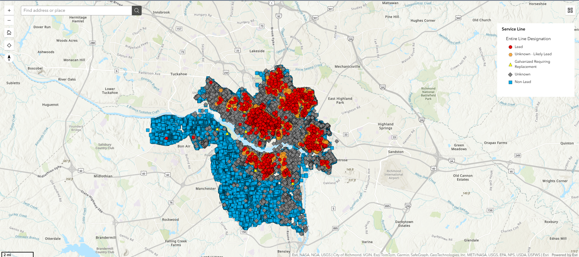
Click here to view the map that identifies the material of water service lines.
Click here to start the survey.
Click here for survey instructions.
Click here if you need plumber assistance.
Stormwater Management
Polluted stormwater runoff is the leading source of surface water pollution in the United States. The Environmental Protection Agency and the Department of Conservation and Recreation have ordered aggressive standards for pollution reduction in the James River.
Each locality developed programs that identified and eliminated non-stormwater discharges in the storm sewer system, including illegal dumping of materials such as paint, leaves, debris, oils and grease into storm sewers.
Richmond is also responsible for the enforcement of programs controlling waste and sediment and reducing pollutants from construction sites - major contributors of urban stormwater pollution.
Each locality must bear the financial responsibility of these mandates since they do not come with state or federal funding.
What is a floodplain?
A floodplain is a natural low lying area next to a river or stream. A floodplain helps spread out and slow down the water during rain events. It is an important part of our water system and effects water quality, wildlife habitat, and stormwater runoff. Building or alterations in the floodplain can cause detrimental effects both upstream and downstream. It is important you know your level of risk and protect yourself, your family and your property.
Can I build in a floodplain?
Building in the floodplain is discouraged in the City. There are strict guidelines before development can occur in the floodplain. All areas of the City have flood elevation protection requirements. Alterations to existing development requires flood proofing to protect from property damage during flooding events. It is important to know that any residential development in the floodplain will be required to carry flood insurance.
To find out more about building in a floodplain, please contact the Water Resources Division at (804)646-7586.
What Causes Flooding?
- Heavy rainfall and large storms can cause flooding events. Excessive amounts of rainfall can happen at any time of the year. Flooding causes high risk to people and properties.
- Flash floods, a rapid flooding of low-lying areas caused by intense rainfall or thunderstorms can tear out trees and destroy building and bridges.
- Snow melt can produce large amounts of runoff because the ground is frozen and hard. Water cannot penetrate or be reabsorbed into the ground -- producing excess runoff, taking pollutants and debris with it.
- New development can change the amount of impervious area that does not absorb rain. This increase in water running across the surface of the ground can cause streams and rivers to become overtopped when historically they did not before new buildings and parking lots were built.
- Blocked inlets can become clogged with debris from trash, sediment, leaves and lawn clippings. Inlets full of trash don't have the capacity to take stormwater away, causing flooding, driving hazards and property damage even during small rain events.
How Can I Protect my Property?
If you build in a floodplain or purchase a property in the floodplain and carry a mortgage, you may be required by your lender to carry flood insurance. Flood insurance is not included in your property insurance. Only the NFIP provides flood insurance. In Virginia it is the property owner's responsibility to find out if a structure is in the floodplain.
Flood Insurance
The City of Richmond participates in the national Flood Insurance Program and has Flood Insurance Rate Maps (FIRMs) of floodplains within the city. Under this program, federally insured or regulated institutions must require flood insurance policies on all new loans for structures in mapped special flood hazard areas (SFHA) recognized by the Federal Emergency Management Agency (FEMA).
To find out more about building in a floodplain, please contact the Water Resources Division at (804) 646-7586.
Flood Protection
The local flood protection system in Richmond has a total length of 17,327 feet (3.28 miles) and protects 750 acres valued at approximately $153 million. It consists of:
- A partially rip-rapped earthen levee
- A concrete floodwall
- Three overlooks (9th & Semmes, Hull & Mayo Bridge, and 12th & Byrd)
- Six roadway closures
- Six railroad closures
- Four personnel closure locations
- Two combined roadway and railroad closures
- Three pump stations
- Three designated ponding areas
The southside alignment comprises three components:
- One earthen levee, approximately 9,000 feet long
- A combination bin wall/levee, approximately 2,000 feet long
- A concrete floodwall, approximately 2,000 feet long
The line of protection extends from just west of the Manchester Bridge, continues along the river's edge to the west side of Interstate 95, turns south, then west, crossing the CSX Railway mainline tracks, and tying into high ground at Goodes Street.
Interior runoff from the watershed in excess of the capacity of the pump station during high river stages will be collected or backed up into the ponding areas. After the river recedes, all ponding areas will drain by gravity through their respective outlets.
The northern alignment is comprised of one component, concrete floodwall which is approximately 4,500 feet long with height variations from five to 29 feet.
The line of protection extends across the mouth of Shockoe Valley to 12th Street. The wall is designed to protect those areas located behind it against a flood with an average recurrence interval of 280 years. The project was dedicated on October 21, 1994, at a cost of $143 million.
Our FEMA (Federal Emergency Management Agency) maps are available online.
Links
Obtaining a Land Disturbing Permit
The Water Resources Division of Public Utilities monitors all land disturbing construction activities, erosion and sediment control, stormwater construction and Chesapeake Bay Act water quality requirements for all new and redevelopment projects.
When do I need a permit?
Any land disturbance equal or greater than 4,000 square feet or equal to or greater than 2,500 square feet in a Chesapeake Bay Protection Area (CBPA) must obtain a separate Richmond Erosion & Stormwater Management Program permit (RESMP.) This permit is for residential and commercial development and includes but is not limited to demolition of structures, new buildings and accessory structures, houses, roads, additions, grading/clearing & grubbing, foundations, changing/redesign of existing onsite storm drainage. Single family dwellings may be eligible for a slightly different process.
Permit requirement flow chart
What is required to submit a Permit?
Step 1: To best prepare your plans for plan review, use the appropriate checklist to ensure all the required information is complete. Stormwater Permit Intake Application Checklist
- Water Resources Environmental Plan Review Checklist
- A completed VESMP permit application
- A completed Responsible land disturber form with a copy of the certification
- A Civil set of drawings containing an E & S plan, Stormwater plan, SWPPP plan (if applicable), Chesapeake Bay site plan (if applicable) and all supporting computations. (The Stormwater Management Design and Construction Standards Manual can assist with all storm drainage design and specifications for proposed projects.) An electronic plan set is required with every application. Be prepared to come with an ftp site url location, thumb or jump drive with plans for downloading.
Where do I submit the VESMP application?
Step 2: The City has an Online Permit Portal for upload applications, documents, paying fees and checking on application status. In addition to have all of the documents listed above, you should know the following information before you submit your application:
- Property owner name, address, phone number and email
- Contractor’s name, address, phone number and email
- Design Firm name, contact person name, address, phone number and email
You will invoiced the remaining required fee. The fees are based on the amount of land disturbance.
What if I’m building one detached single family house?
All Single Family Dwellings (SFD) disturbing 4,000 square feet of land (or 2,500 square feet in a CBPA area) or more are required to submit a separate VESMP permit for all single family dwellings in or out of a common plan of development (subdivision). A building permit does not grant permission to construct a house. Single Family dwellings may be eligible for an Agreement In Lieu of Plan (AILP) in place of submitting a complete set of civil engineering plans. A small site plan along with a bond is required for those SFDs that are eligible for the AILP.
Use the Online Permit Portal to submit the application. Follow the steps under “Where Do I submit the VESMP Application.”
The following documents are required to be submitted for all SFDs:
- A completed VESMP permit application
- A completed Responsible land disturber form with a copy of the certification
- A small site plan (Example of small site plan here.) showing the following information:
-
- the proposed dwelling
- the adjacent street(s)
- The adjacent parcel(s)
- The limits of disturbance (LOD)
- Silt fence protecting the site (SF)
- A construction entrance (CE)
-
What if I’m building multiple houses at one time?
Building multiple structures on different but adjoining lots over a period of time is considered a Common Plan of Development and requires the submission of a VESMP permit. Follow the instructions for “How do I submit
What is the final step?
Step 3: Your plan reviewer will notify you when the plan is approve and ready for permit issuance. Prior to any VESMP permit approval the following information must be submitted:
- An unsigned Stormwater Utility Maintenance Agreement (SUMA) and plat
- E & S Bond package to include:
- The Bond payment. (A performance surety is required for every land disturbing project except City of Richmond Capital Improvement Projects (CIP).)
- A signed E&S Developers Agreement
- The E & S Control Measures spreadsheet
Additional Information:
- Bond amounts are determined by the amount of E & S measures required on the plans. Should you not complete your project, your surety will be utilized towards stabilizing the site and you will be billed for the remaining amount.
- The bond can be paid with a surety bond, check, or an irrevocable letter of credit. Sureties are submitted directly to: DPU Water Resources at 1801 Commerce Road. The E & S Developer's Agreement (DA) must be signed and E & S Control Measures Worksheet must be submitted along with the surety.
- The DA must be signed by the director (this can take up to a week).
- Written verification of the final inspection from the City of Richmond Erosion and Sediment Control Inspector is required before any portion of the surety is released. It is the owner's responsibility to request an inspection to obtain a surety release. The final inspection shall not be completed prior to 75% of living perennial vegetation being established. See Virginia Department of Environmental Quality C-SSM-10 Permanent Seeding Section 3.0 Planning and Considerations.
- Surety will be released once 75% vegetation has been established at the final inspection. Bonds should be release in 30 days.
- SUMAs must be submitted when a non-structural and structural best management practice (BMP) is proposed.
- The SUMA should be completed but not signed or notarized. It will be reviewed for correctness and returned for signature and notarizing.
- The final SUMA must be submitted to the City of Richmond’s City Attorney’s Office via the instructions listed here.
Chesapeake Bay Buffer Areas (CBPA)
The Chesapeake Bay Resource Protection Area Flyer is available here.
Under the Chesapeake Bay Act framework, the City of Richmond is responsible for implementing its Bay Act program. The City of Richmond has adopted ordinance provisions that incorporate the performance criteria required by the Bay Act. Those provisions include City of Richmond, VA Municipal Code, Chapter 14 – Division 4: Land Use and Development Performance Criteria
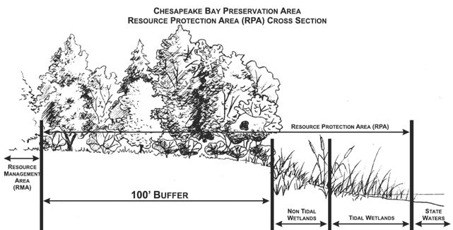
The Chesapeake Bay Protection Areas (CBPA) are special areas of the city that are designated as having an impacting on or draining to the Chesapeake Bay. These areas are divided into area buffer areas, the Resource Management Area (RMA), the Resource Protection Area (RPA) and the Intensely Developed Area (IDA). . Development within the RPA and the 50 foot buffer land ward of a perennial water body, is restricted and requires mitigation of the impacts to the area beyond water quality. The Chesapeake Bay Information Manual provides guidance to the public on the Chesapeake Bay and its requirements. The Riparian Buffer Manual provides guidance on the RPA
Locally designated CBPA have been depicted on adopted Bay Act maps for the City of Richmond. These maps are to be used as a guide for applicants and local staff as to the general location of RPAs and RMAs on lots and parcels and should be used for planning purposes only. Once a project is proposed, a site-specific location of the RPA and the RMA must be determined.
The locally adopted CMA can be found here: Interactive Chesapeake Bay Map
The VA Department of Environmental Quality (DEQ) has enacted Stormwater regulations that require development in these areas to meet new water quality standards. Using specific data regarding impervious areas, the amount Water quality treatment for each site is determined using the Runoff Reduction Spreadsheet.
Using specific data regarding impervious areas, the amount of phosphorus to be removed from the water will be determined. Land development of one (1) acre or greater in non CBPA will also be required to provide water quality treatment as part of the REMSP permit approval.
For development criteria for RPA, refer to City of Richmond, VA Municipal Code Sec. 14-264. Applicants must submit an Application for Relief from Requirements of the Chesapeake Bay Preservation Program.
Useful Links
- City of Richmond Code Chapter 14 - Floodplain Management, Erosion and Sediment Control, and Drainage (Municode)
- Department of Environmental Quality (DEQ)
- Runoff Reduction Method
- Virginia Stormwater BMP Clearing House
- Interactive Chesapeake Bay Map
- Virginia Stormwater Management Handbook
- Stormwater Management Design and Construction Standards Manual
- FEMA Floodplain Map Service Center
- VA Flood Risk Information
- NFWF Wetlands Inventory
- Planning & Development Review
Document Library
- RESMP Permit Application
- Erosion and Stormwater Management Permit (RESMP) Process Quick Sheet
- Water Resources Environmental Check List
- Water Resources Guidance Manual
- E & S Developers Agreement
- Responsible Land Disturber form
- Stormwater Utility Maintenance Agreement (SUMA) Instructions
- Stormwater Utility Maintenance Agreement (SUMA)
The Chesapeake Bay Resource Protection Area Flyer is available here.
The City of Richmond is committed to helping the Commonwealth improve and preserve water quality for the 64,000 square mile watershed that flows to the Chesapeake Bay.
The Chesapeake Bay program was adopted in 1981 as required by Virginia General Assembly to create and preserve buffer areas around local streams and rivers to help improve water quality.
New and redevelopment construction projects within these designated Chesapeake Bay Protection Areas (CBPAs) are required to provide some type offset or mitigation to improve the quality of the water before the runoff enters local waterways which ultimately flow to the Bay.
When developing within a CBPA there are some key points to remember:
Resource Management Area
A Resource Management Area (RMA) is contiguous to the entire inland boundary of a Resource Protection Area (RPA). The following land categories shall be considered for inclusion in the Resource Management Area and, where mapping resources indicate the presence of these land types contiguous to the resource protection area, should be included in designations of RMAs:
- 100-year floodplains
- Highly erodible soils including steep slopes
- Non-tidal wetlands not included in the RPA
- 500-foot buffers (protect RPAs and those other areas listed)
- 600-foot buffers outward from the center of the stream in areas where the RMA has no site specific evaluation.
Resource Protection Area
A Resource Protection Area (RPA) consists of lands adjacent to water bodies with perennial flow that have an intrinsic water quality value due to the ecological and biological processes they perform or lands that are sensitive to impacts which may cause significant degradation to the quality of state waters. The City has included the following areas:
- Tidal wetlands
- Non-tidal wetlands contiguous to tidal wetlands or water bodies with perennial flow
- Tidal shores
- Other land considered necessary for water quality protection
- Buffered areas 100 feet landward of and adjacent to those listed above.
An Intensely Developed Area (IDA) is an overlay to the RPA, this category includes "areas of existing development and infill sites where little of the natural environment remains." Development in an IDA is treated as redevelopment, in which case the performance requirement is for a ten percent (10%) reduction in nonpoint source pollution where runoff is not already treated by a BMP.
Water Quality Impact Assessment (WQIA) is a narrative that identifies the impacts of proposed development on water quality and lands in the Resources Protection Areas consistent with the goals and objectives of the Clean Water Act, City Code, and the city's programs, and to determine specific measures for mitigation of those impacts. A WQIA is required for all development and encroachments into a RPA.